

GPS Nav Survey Camera
Ivan Blajic · Navigation
Independent analytics for this App Store listing. AppTracker is not affiliated with Ivan Blajic.
Chart standing · US
What changed · US
Listing changes AppTracker has observed for this app in this storefront — new versions, price moves, rating shifts, and store copy.
- app redesign and new features - bug fixes and improvements
Ratings breakdown · US
The star breakdown behind this app's rating in this storefront.
In-app purchases · US
What this app sells inside itself, grouped by kind and priced for this storefront.
Screenshots




Keywords this app targets
Search terms AppTracker associates with this app — estimates, not search volume. ❝ = in the app's title; a highlighted number is its current position for that term.
Similar apps
Competitors and close alternatives, as estimated by AppTracker.
 GPS Camera 55. Field Survey
Kalimex-Consulting s.r.o.
2 shared topics · 3 shared title words
GPS Camera 55. Field Survey
Kalimex-Consulting s.r.o.
2 shared topics · 3 shared title words
 Solocator - GPS Field Camera
Civi Corp
1 shared topic · 2 shared title words
Solocator - GPS Field Camera
Civi Corp
1 shared topic · 2 shared title words
 BuildStamp
Jamie Ward
BuildStamp
Jamie Ward
 Site Visit Assistant - Reports
Transforming Ninja Limited
Site Visit Assistant - Reports
Transforming Ninja Limited
 Site Auditor: Field Proj Mgmt
Royal Allen
Site Auditor: Field Proj Mgmt
Royal Allen
 SiteProof Camera
YOUHEE LEE
1 shared title word
SiteProof Camera
YOUHEE LEE
1 shared title word
 Repolog: Photo Site Reports
MAKOTO NAKAGAWA
Repolog: Photo Site Reports
MAKOTO NAKAGAWA
 Timemark: Photo Proof for Work
OCEAN GALAXY PTE. LTD.
Timemark: Photo Proof for Work
OCEAN GALAXY PTE. LTD.
About
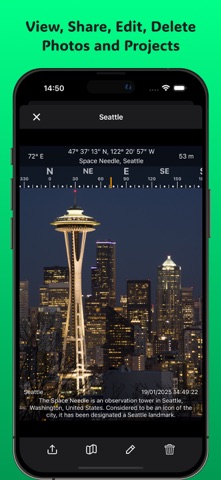
Take timestamped, GPS-stamped photos on the job - and turn them into branded PDF reports in minutes. Built for contractors, builders, inspectors, and field crews who need proof of what was done, where, and when. No subscription. One one-time upgrade unlocks everything, forever. WHY CREWS USE IT • Prove your work: every photo stamped with date, time, GPS coordinates, address, and more • Win disputes: timestamped evidence of existing conditions, concealed work, and completed jobs • Look professional: branded PDF photo reports with your logo - emailed before you leave the site STAMP EVERYTHING THAT MATTERS • Date & time, GPS coordinates (Lat/Long, UTM, MGRS), street address, altitude, compass heading • Project name, job number, client - plus your own custom fields • Stamps are burned into the photo; untouched originals are always preserved • GPS stamping works even with no cell signal BUILT FOR THE JOB SITE • Projects keep every job organized: client, site address, job number, status • Before & after pairing with side-by-side report pages • Draw on photos: arrows, boxes, and text to call out defects and snags • Voice notes with automatic transcription • Stamped video capture • Level indicator and lens picker for clean, straight shots • Fast gallery with search, filters, batch actions, and a map of every photo REPORTS & EXPORT • Branded PDF photo reports with cover page, logo, and signature • Side-by-side before/after pages • CSV and KML export for spreadsheets and Google Earth • ZIP export of stamped photos or originals • Share anywhere: email, Messages, Files, cloud drives SYNC & PRIVACY • iCloud sync keeps your library on iPhone and iPad (Pro) • Your photos stay yours: stored on your device and your iCloud - never on our servers, no account required WHO IT'S FOR General contractors, subcontractors, electricians, plumbers, HVAC, roofers, landscapers, painters, home inspectors, insurance adjusters, property managers, engineers, and safety officers — anyone who documents work in the field. FREE VS PRO Free: unlimited stamped photos with standard fields, 2 active projects, gallery search & map, before/after tagging, ZIP export, and watermarked PDF reports (first 10 photos). Pro (one-time purchase - no subscription, ever): unlimited projects, unrestricted branded reports, iCloud sync, custom stamp fields, voice notes & dictation, stamped video, CSV/KML export, and unlimited annotations. Put proof behind every job - download now and take your first stamped photo in seconds.
What's new · 2.0
- app redesign and new features - bug fixes and improvements
Details