

San Francisco Subway map
Yaroslav Mykolaienko · Navigation
Independent analytics for this App Store listing. AppTracker is not affiliated with Yaroslav Mykolaienko.
Chart standing · US
What changed · US
Listing changes AppTracker has observed for this app in this storefront — new versions, price moves, rating shifts, and store copy.
A wider Bay Area network. More ways to explore San Francisco. This version brings together broader public transport coverage and city discovery tools, so you can plan the journey and make more of the destination. Move beyond a rail-only view with a bundled network of 147 routes and 5,198 stops, then explore station guides, photo spots and suggested visit plans. EXPANDED TRANSPORT COVERAGE • BART and Muni Metro alongside cable cars and historic streetcars. • Local, rapid and night bus categories, plus regional bus connections. • Caltrain, SamTrans and AC Transit Transbay routes. • Golden Gate Transit, Golden Gate Ferry and San Francisco Bay Ferry. • A connected network built from seven official transport data sources. The map and planner now bring these transport categories into one consistent experience. Browse the network by category, choose the services you want to include and look at how stops connect across San Francisco, the Peninsula and the East Bay. Use the wider coverage when your trip needs more than a single train line. MORE CONTEXT FOR YOUR ROUTE Review individual trip legs, stops, transfers, walking connections and estimated travel time. See the trip on the map before setting out and identify where to change. Plan around the transport categories that suit your journey, whether you are heading downtown, connecting with commuter rail or exploring across the bay. The bundled transport network and route calculations work offline. Online map imagery and external services still need an internet connection. Estimated durations use static network data; they are not a promise of current departures, live arrivals or disruption-free travel. CITY GUIDES CONNECTED WITH YOUR JOURNEY Explore station information, neighborhood highlights and nearby attractions. The guide helps turn a stop on the map into a place to discover, with ideas around downtown, the waterfront, Golden Gate Park, Chinatown, the Castro and other Bay Area destinations. Read the practical context before choosing the next part of your day. PHOTO SPOTS AND VISIT PLANS Find inspiration in waterfront walks, architecture and photo locations. Suggested plans for one to seven days help you organise a short break or a longer stay. Open places in Maps when you are ready to continue and connect sightseeing ideas with the transport tools already in the app. AUDIO GUIDE AND DAYLIGHT TOOLS Listen to spoken guide content while exploring. Check San Francisco sunrise and sunset times for the date you choose, and consider daylight when arranging a walk or a visit to a photo spot. These tools sit alongside the city guide, so useful travel details are easier to keep together. AIRPORT AND TRAVEL INFORMATION Prepare for SFO, OAK or SJC with airport guidance and transport context. Review fare and payment references, check transfer notes and open official sources for current details. Keep useful addresses together and access practical visitor information, emergency contacts and city services from the app's travel sections. Travel tools also link to external options for hotels, flights, tours, car rentals and mobile data. Availability and conditions depend on the provider. The app does not sell transit tickets or guarantee external bookings, airport status, transport fares or service availability. TRY THE WIDER NETWORK Choose a starting point and a destination, select your transport categories and review the route. Then look for nearby attractions, save the addresses you need and build a plan for the next day. Connect everyday travel with a new view of San Francisco. San Francisco Subway Map remains an independent travel companion, unaffiliated with BART, SFMTA or other transport operators. Check official service information and opening hours before traveling. App Store translations describe the features; language support within individual screens and external services may differ. Explore the map, plan your next connection and discover more of the Bay Area.
In-app purchases · US
No in-app purchases.
Screenshots




About
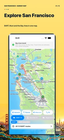
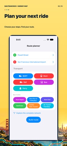
Explore San Francisco with a subway map, offline route planner and city guide in one app. Find your way across BART, Muni Metro, buses, Caltrain and Bay Area ferries, then discover what to see near your next stop. From an airport arrival to a waterfront afternoon or your daily commute, San Francisco Subway Map helps you connect the journey with the destination. Keep transport information, sightseeing ideas and useful travel tools together on your iPhone or iPad. YOUR BAY AREA TRANSIT MAP See routes and stops on an interactive map. Browse BART and Muni Metro alongside cable cars, historic streetcars, local and regional buses, commuter rail and ferries. The bundled transport network contains 147 routes and 5,198 stops drawn from seven official data sources. Explore San Francisco, the Peninsula and the East Bay with one consistent view of the network. PLAN A ROUTE BEFORE YOU GO Choose your starting point and destination, select the transport categories you want to use and review the trip. See the route's legs, stops, transfers, walking connections and estimated travel time. Follow the journey on the map and understand where to change. Use the planner for a familiar commute, an unfamiliar station or a day of sightseeing across the bay. OFFLINE ESSENTIALS, ONLINE MAPS The bundled transit network, route calculations and rail map are available without an internet connection. Keep the essentials close when mobile reception is limited or you are traveling without roaming. Interactive map imagery, external websites and online travel services need a connection. Travel estimates are based on static network data and do not guarantee current departures or live service conditions. DISCOVER MORE AROUND EACH STOP Pair your transport plan with a city guide. Browse station information, nearby attractions, neighborhood highlights and practical suggestions for the next part of your day. Explore downtown, the waterfront, Golden Gate Park, Chinatown, the Castro and destinations beyond the city center. Find inspiration for a short visit or use the guide to build a fuller Bay Area itinerary. MAKE THE MOST OF YOUR VISIT • Discover photo spots, waterfront walks and architecture. • Explore suggested visit plans for one to seven days. • Listen to spoken guide content using the audio guide. • Check San Francisco sunrise and sunset times for a selected date. • Open places in Maps to continue your journey. • Keep useful addresses together for later reference. AIRPORTS AND PRACTICAL TRAVEL Find guidance for SFO, OAK and SJC, with airport information and transport context to help prepare your arrival or departure. Read fare and payment references, review transfer information and open official sources for details. Travel sections provide access to hotels, flights, tours, car rentals and mobile data options through external providers. Their availability and terms depend on the provider. HELPFUL INFORMATION WITHIN REACH Access emergency and non-emergency contact information, city services and practical visitor tips. Organize your plans before leaving the hotel, compare the transport options that suit your day and keep the next stop in view. The app is useful for visitors, commuters and students who want to understand how San Francisco and the Bay Area fit together. San Francisco Subway Map is an independent travel companion and is not affiliated with BART, SFMTA or other transport operators. Always confirm current service, fares, opening hours and airport information with official sources. A translated App Store description does not mean every app screen or external service supports that language. Start with a downtown station, look at the connections towards the waterfront or explore a cross-bay trip. The map, route result and place information let you prepare each part of the day before setting out. Open the map. Plan your journey. Discover San Francisco, one stop at a time.
What's new · 3.0
A wider Bay Area network. More ways to explore San Francisco. This version brings together broader public transport coverage and city discovery tools, so you can plan the journey and make more of the destination. Move beyond a rail-only view with a bundled network of 147 routes and 5,198 stops, then explore station guides, photo spots and suggested visit plans. EXPANDED TRANSPORT COVERAGE • BART and Muni Metro alongside cable cars and historic streetcars. • Local, rapid and night bus categories, plus regional bus connections. • Caltrain, SamTrans and AC Transit Transbay routes. • Golden Gate Transit, Golden Gate Ferry and San Francisco Bay Ferry. • A connected network built from seven official transport data sources. The map and planner now bring these transport categories into one consistent experience. Browse the network by category, choose the services you want to include and look at how stops connect across San Francisco, the Peninsula and the East Bay. Use the wider coverage when your trip needs more than a single train line. MORE CONTEXT FOR YOUR ROUTE Review individual trip legs, stops, transfers, walking connections and estimated travel time. See the trip on the map before setting out and identify where to change. Plan around the transport categories that suit your journey, whether you are heading downtown, connecting with commuter rail or exploring across the bay. The bundled transport network and route calculations work offline. Online map imagery and external services still need an internet connection. Estimated durations use static network data; they are not a promise of current departures, live arrivals or disruption-free travel. CITY GUIDES CONNECTED WITH YOUR JOURNEY Explore station information, neighborhood highlights and nearby attractions. The guide helps turn a stop on the map into a place to discover, with ideas around downtown, the waterfront, Golden Gate Park, Chinatown, the Castro and other Bay Area destinations. Read the practical context before choosing the next part of your day. PHOTO SPOTS AND VISIT PLANS Find inspiration in waterfront walks, architecture and photo locations. Suggested plans for one to seven days help you organise a short break or a longer stay. Open places in Maps when you are ready to continue and connect sightseeing ideas with the transport tools already in the app. AUDIO GUIDE AND DAYLIGHT TOOLS Listen to spoken guide content while exploring. Check San Francisco sunrise and sunset times for the date you choose, and consider daylight when arranging a walk or a visit to a photo spot. These tools sit alongside the city guide, so useful travel details are easier to keep together. AIRPORT AND TRAVEL INFORMATION Prepare for SFO, OAK or SJC with airport guidance and transport context. Review fare and payment references, check transfer notes and open official sources for current details. Keep useful addresses together and access practical visitor information, emergency contacts and city services from the app's travel sections. Travel tools also link to external options for hotels, flights, tours, car rentals and mobile data. Availability and conditions depend on the provider. The app does not sell transit tickets or guarantee external bookings, airport status, transport fares or service availability. TRY THE WIDER NETWORK Choose a starting point and a destination, select your transport categories and review the route. Then look for nearby attractions, save the addresses you need and build a plan for the next day. Connect everyday travel with a new view of San Francisco. San Francisco Subway Map remains an independent travel companion, unaffiliated with BART, SFMTA or other transport operators. Check official service information and opening hours before traveling. App Store translations describe the features; language support within individual screens and external services may differ. Explore the map, plan your next connection and discover more of the Bay Area.
Details