

Wise Pilgrim Caminho Nascente
Wise Pilgrim SL · Travel
Independent analytics for this App Store listing. AppTracker is not affiliated with Wise Pilgrim SL.
Chart standing · US
What changed · US
Listing changes AppTracker has observed for this app in this storefront — new versions, price moves, rating shifts, and store copy.
Today's walk is now a tap away on the Yellow X page: how far you've come, how far to tonight's stop, and the Yellow X follows your itinerary. New on the Dashboard: the Pilgrim Roads wall map, and luggage storage and shipping in Santiago. The pronunciation guide now tells you when new places are ready. Preparation for new features for winter pilgrims. And fresh data on every route. Buen Camino!
Ratings breakdown · US
The star breakdown behind this app's rating in this storefront.
In-app purchases · US
What this app sells inside itself, grouped by kind and priced for this storefront.
Screenshots





About
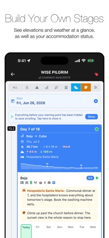
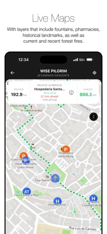
No Signup. No Login. Celebrating their 14th year online, the Wise Pilgrim Guides are the go-to source of up-to-date information on the Camino de Santiago. Completely Rebuilt for 2026 Your Complete Guide to the Caminho Nascente A Portuguese route from the Algarve, crossing the entire length of Portugal. 1059 km from Tavira to Santiago de Compostela through Portugal. Yellow X The best features from our beloved geolocation toolkit—see exactly how far you are from the next town or the nearest albergue. Dynamic Elevation Profile Completely reimagined and interactive. Tap anywhere to see distances to points along your route. See where you are on the profile in real time. One complete elevation from start to finish, uninterrupted by page folds. Improved Maps Offline and online versions of beautiful topographical maps. More interactive, more informative, more helpful when you're standing at a fork in the path. Offline map tiles now available as an in-app purchase. Live Wildfire Map See active wildfires across Spain and Portugal, updated daily from the EU's Copernicus fire service (EFFIS), plus this season's burnt areas along your route. A quick safety check before you set out. Smarter Updates Over-the-air updates only download what's changed. No more full app downloads eating through your data plan. Itinerary Planner Built-in planner, with the ability to import your plan from wisepilgrim.com too. Pilgrim Tips Leave tips for pilgrims following behind you, and benefit from those left before you. Accommodation Directory A full directory of albergues, camping, hotels, pensions, paradors, and casas rurales. With special attention to those that can be booked online. Stageless Guide No more "stage anxiety" or guide-created bottlenecks. Photos Photos of albergues, monuments and other points of interest along the way. Comments Albergue closed early for the season? Have a restaurant to share, or one to warn others about? Every location gives you the opportunity to leave a comment and read comments left by others. No registration necessary. Notes Jot down a note on any town, albergue, or stop on the route, or drop a pin on the map for water, viewpoints, photo spots, or places to come back to. Everything gathers on one page in order along the Camino, ready to search and export. Your notes stay private on your phone. Share & import — swap itineraries and notes with fellow pilgrims by QR code or file. Back up your plan and notes to a file, so nothing's lost when you change phones. ¡Buen Camino and thank you for your support!
What's new · 6.7.6
Today's walk is now a tap away on the Yellow X page: how far you've come, how far to tonight's stop, and the Yellow X follows your itinerary. New on the Dashboard: the Pilgrim Roads wall map, and luggage storage and shipping in Santiago. The pronunciation guide now tells you when new places are ready. Preparation for new features for winter pilgrims. And fresh data on every route. Buen Camino!
Details