

Air Navigation - VFR & IFR
Flygo-Aviation Ltd · Navigation
Independent analytics for this App Store listing. AppTracker is not affiliated with Flygo-Aviation Ltd.
Chart standing · US
What changed · US
Listing changes AppTracker has observed for this app in this storefront — new versions, price moves, rating shifts, and store copy.
In this update: • Offline readiness — see at a glance whether a flight can be flown without a connection. A route, a Direct To or a saved route is checked along the track and 10 NM either side: the map, the VFR chart and the terrain of every region, the databases, the airport diagrams, and the NOTAMs and weather on the device. One button downloads everything the flight needs, and a capsule on the map shows the progress. • Data status — More ▸ Data status is a pre-flight check: GPS and location access, the connection, how fresh the weather and NOTAMs are, offline maps and terrain along your route, and the databases; one tap copies a summary for support. • Airports — a new, smaller database: US frequencies and navaids from the FAA’s official NASR data, and current frequencies, runways and about 2,000 more fields in Europe from openAIP. • Airport symbols — large and medium airports are drawn with their own runway layout. • Fixes — SIGMETs, AIRMETs and pilot reports refresh every five minutes again; “Show private” hides private fields again; map symbols come back after Center; a paused download no longer resumes on its own. As always, this release also includes bug fixes and performance improvements. Blue skies!
Ratings breakdown · US
The star breakdown behind this app's rating in this storefront.
In-app purchases · US
What this app sells inside itself, grouped by kind and priced for this storefront.
Screenshots





About
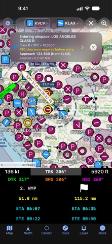
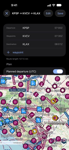
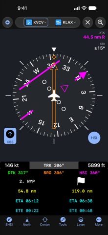
Air Navigation - VFR & IFR is the ultimate flight planning and navigation app for pilots. Plan VFR or IFR flights with worldwide charts, real-time weather (METAR/TAF), NOTAMs, airspace alerts, terrain awareness, airport information, and more – all in one easy-to-use app. Download and try PRO free for 1 month! * Features: • Route planning Create and save routes with 50,000+ airports, navaids, and waypoints. • Maps and charts, connected to GPS Navigate with updated sectional and en-route charts in the US and EU **. Customize maps with airports, airspaces, navaids, and weather layers. • Weather Access worldwide METAR and TAF reports. • Offline use Download maps, charts, and terrain for offline flying. • Terrain avoidance system *** Terrain coloured red and yellow against your GPS altitude in the air, and on the ground against a preview altitude above the field — so what is red is what stands in the way of the departure. • Airspace alerts A banner names the airspace you are approaching or entering, its class and vertical limits, the distance to its boundary, and the frequency to call — derived from the aerodrome's published data, so always verify it. • EHSI / RMI instruments Fly procedures with digital navigation instruments. • Nearby airports Quickly find alternate airports, their distance, and relative direction. • Real-time flight information Heading, track, distance, ETA, ETE, speed, and waypoints. • iCloud synchronization Sync your data between multiple devices. • Airport information & diagrams Runways, frequencies, navaids, NOTAMs, and weather data. Runway diagrams with the wind — now or at any TAF time — and to-scale airport diagrams with taxiways and your position. • NOTAMs Runway closures highlighted, cancelled filings followed, duplicate filings folded together, and the distance to each one. • User points Add custom waypoints by tapping the map or entering coordinates. • Quick tap mode Tap any location to view airspace, frequencies, SIGMETs, AIRMETs, and runway data. The airspace column draws every airspace above the point to its height. • SIGMETs & AIRMETs Global weather advisories displayed on the map. • Advanced search Find airports by name, city, ICAO, or IATA. • Units & north reference Imperial (US) or metric units, magnetic or true north. • Taxiing & runway awareness The airport diagram as a taxi chart: your aircraft on the taxiways, your taxi route with hold-short crossings, and runway alerts, shown and spoken. • Built-in user guide Step-by-step help with screenshots, without leaving the app. * Subscriptions: BASIC and PRO. Unlimited charts, terrain, and the 1-month trial are included with PRO. BASIC offers a 2-week trial. ** EU sectional charts are available in Belgium, Germany, Finland, the Netherlands, Denmark, Poland, Sweden, Bulgaria, Croatia, Greece, Hungary, Italy, Slovenia, the Czech Republic, Malta, Austria, Romania, Switzerland, and Slovakia. Additional charts are available in South Africa and Namibia. Charts provided by Open Flight Maps. Airspace data: openAIP (openaip.net, CC BY-NC 4.0) and the FAA. *** Terrain data available from 60°N to 57°S. Disclaimer: This is not a certified flight instrument. Pilots must not rely solely on the app for navigation. Always use approved avionics for flight safety. Terms of use: https://www.flygo-aviation.com/air-navigation-terms-of-use/ Privacy policy: https://www.flygo-aviation.com/air-navigation-privacy-policy/
What's new · 2.79
In this update: • Offline readiness — see at a glance whether a flight can be flown without a connection. A route, a Direct To or a saved route is checked along the track and 10 NM either side: the map, the VFR chart and the terrain of every region, the databases, the airport diagrams, and the NOTAMs and weather on the device. One button downloads everything the flight needs, and a capsule on the map shows the progress. • Data status — More ▸ Data status is a pre-flight check: GPS and location access, the connection, how fresh the weather and NOTAMs are, offline maps and terrain along your route, and the databases; one tap copies a summary for support. • Airports — a new, smaller database: US frequencies and navaids from the FAA’s official NASR data, and current frequencies, runways and about 2,000 more fields in Europe from openAIP. • Airport symbols — large and medium airports are drawn with their own runway layout. • Fixes — SIGMETs, AIRMETs and pilot reports refresh every five minutes again; “Show private” hides private fields again; map symbols come back after Center; a paused download no longer resumes on its own. As always, this release also includes bug fixes and performance improvements. Blue skies!
Details