

Old Satellite Map JAPAN
Shigeo Nakamoto · Navigation
Independent analytics for this App Store listing. AppTracker is not affiliated with Shigeo Nakamoto.
Chart standing · US
What changed · US
Listing changes AppTracker has observed for this app in this storefront — new versions, price moves, rating shifts, and store copy.
- HD imagery is available for the 1974-78 aerial photos. On other eras the HD button is dimmed and explains why when tapped. - The era dial now checks the actual imagery to see whether photos exist for that era. - Fixed the split slider being hard to grab at the edges and jumping to a wrong position. - Fixed dialogs overlapping the ad at the bottom, which could hide their buttons. - Fixed several cases where the app could close unexpectedly, including right after launch.
In-app purchases · US
What this app sells inside itself, grouped by kind and priced for this storefront.
Screenshots

Keywords this app targets
Search terms AppTracker associates with this app — estimates, not search volume. ❝ = in the app's title; a highlighted number is its current position for that term.
Similar apps
Competitors and close alternatives, as estimated by AppTracker.
 Tokyo Jisou Maps
Japan Map Center, Inc.
3 shared topics
Tokyo Jisou Maps
Japan Map Center, Inc.
3 shared topics
 Tokyo JisouMaps (Old Version)
Japan Map Center, Inc.
2 shared topics · 1 shared title word
Tokyo JisouMaps (Old Version)
Japan Map Center, Inc.
2 shared topics · 1 shared title word
 Kansai Jisou Maps
Japan Map Center, Inc.
Kansai Jisou Maps
Japan Map Center, Inc.
 国土マップR
keiji matsumoto
国土マップR
keiji matsumoto
 Satellite Map - Earth View
ANKAGIS YAZILIM ANONIM SIRKETI
1 shared topic · 3 shared title words
Satellite Map - Earth View
ANKAGIS YAZILIM ANONIM SIRKETI
1 shared topic · 3 shared title words
 Japan Travel - Smart Transit
NAVITIME JAPAN CO.,LTD.
1 shared topic · 1 shared title word
Japan Travel - Smart Transit
NAVITIME JAPAN CO.,LTD.
1 shared topic · 1 shared title word
 WeatherMap Browser Japan
Pawana
WeatherMap Browser Japan
Pawana
 kokoii: Japan Travel Photo Map
keita suzuki
2 shared title words
kokoii: Japan Travel Photo Map
keita suzuki
2 shared title words
About
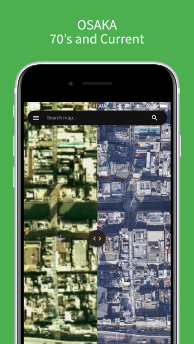
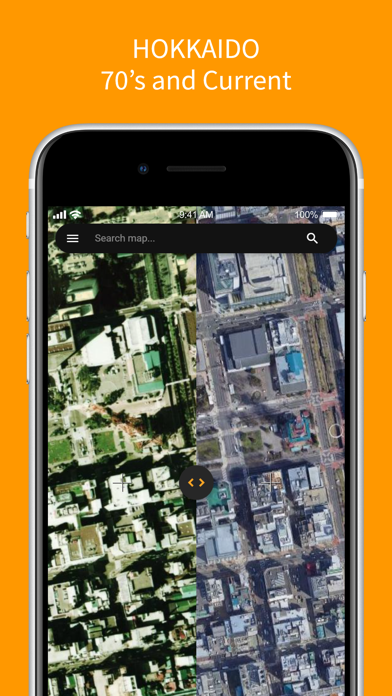
A map app that displays aerial photographs of Japan taken in the 1970s. You can compare today's map side by side with 1970s aerial photography. [Features] - Displays Google Maps and 1970s aerial photographs side by side - Detects and shows your current location - Switch to full screen to explore the 1970s map - Switch between 9 generations with the year dial: 1928 / 1936-1942 / 1945-1950 (US Army) / 1961-1969 / 1974-1978 / 1979-1983 / 1984-1986 / 1988-1990 / 2007-2012 - Coverage differs by year and location. The app automatically detects which years are available at the point you are viewing (1974-1978 covers the whole country; 1928 covers the city of Osaka; 1936-1942 covers Tokyo's 23 wards and the Osaka area) [Subscription] - To hide ads, please purchase the subscription at "Purchase" menu in this app. - When changing device, you can restore it for free at "Purchase" menu in this app only if you use the device with the same Apple ID as when you purchased it. - To cancel your subscription, you can cancel it in "Settings app" > "Your name" > "Subscriptions". [Source] - The historical aerial photographs are provided by the Geospatial Information Authority of Japan (GSI). [Terms of service] https://www.apple.com/legal/internet-services/itunes/dev/stdeula/
What's new · 4.7.8
- HD imagery is available for the 1974-78 aerial photos. On other eras the HD button is dimmed and explains why when tapped. - The era dial now checks the actual imagery to see whether photos exist for that era. - Fixed the split slider being hard to grab at the edges and jumping to a wrong position. - Fixed dialogs overlapping the ad at the bottom, which could hide their buttons. - Fixed several cases where the app could close unexpectedly, including right after launch.
Details